


When Clayfield Was the End of the Line for Brisbane’s Northern Travellers

Long before Sandgate Road became the transport corridor residents know today, Clayfield sat at an important junction between Brisbane’s tram network and northern districts beyond the tracks.


Clayfield’s transport role took shape around the turn of the 20th century. The North Coast railway opened in 1882, with a line running from Eagle Junction through Clayfield towards Ascot, while a tram line along Sandgate Road reached Wagner Street in 1901. Brisbane City Council heritage records say the tram extension helped open Clayfield to further residential development.

Clayfield joins the tram network

The Sandgate railway opened on 10 May 1882, with regular services beginning the following day. During the 1890s, the number of people travelling into the city from Albion, Mayne, Wooloowin, Eagle Junction, Clayfield and Hendra more than doubled. By the turn of the century, tram services linked Albion with Clayfield and the city.

The Sandgate Road tram reached Wagner Street in 1901, adding another transport connection through Clayfield. Council heritage research later linked the tram line with the suburb’s continued residential growth.

Public transport also influenced the development of homes and flats along the corridor. Heritage records for buildings in Clayfield note that access to the tram made travel to and from the city easier and contributed to growth along Sandgate Road.

By 1930, private bus operators were running separate services between Nundah and the Clayfield tram terminus and between Virginia and the Clayfield tram terminus. Records from 10 November that year list James Edgar White and William White as operators of both routes.

Private buses feed the terminus

The feeder network was still operating two decades later. A February 1950 route list shows a service running from the Clayfield tram terminus to Wavell Heights and East Nundah, while another connected Clayfield with Virginia and Nudgee.

Photo Credit: Old Brisbane/Facebook

Passengers from those northern districts could therefore reach Clayfield by bus and transfer to the tram network for the journey towards the city.

Life grew around the terminus

Transport also helped shape activity around the terminus precinct.

The Savoy Picture Theatre stood on the edge of the Clayfield shopping centre, just south of the tram terminus. Historical accounts record patrons watching silent films from canvas deckchairs before the open-air theatre was later roofed.

Other local institutions benefited from Clayfield’s improving transport connections. Brisbane City Council heritage research on St Agatha’s Catholic Church identifies the Sandgate and Pinkenba railway lines and the tramways to Ascot and Clayfield as major contributors to the suburb’s rapid development.

An oral history preserved by the Australians at War Film Archive also records the terminus as part of everyday working life. Leslie Walker recalled working for a butcher at the Clayfield tram terminus before travelling into town as a telegraph and newspaper boy, using the tram system as part of his daily rounds.

From trams to buses

Clayfield’s transport role changed again as Brisbane’s public transport system moved away from trams.

A heritage-listed waiting shelter still stands on Sandgate Road near Reeve Street. Brisbane City Council records identify it as a BCC bus waiting shed dating from the postwar period. The shelter generally conforms to a standard design prepared by the Department of Works and signed off by City Architect Frank Costello in 1945.

Photographs held by the State Library of Queensland also preserve Clayfield’s place in the final years of Brisbane’s tram system. The Dearden family collection includes a series titled “The last of the trams”, with images taken in Brisbane and Clayfield.


Sandgate Road remains a major transport corridor through Clayfield, but its role reaches back more than a century. Before direct suburban bus networks became the norm, Clayfield was one of the places where private buses from the northern outskirts met Brisbane’s electric tram system.

Published 7-Oct-2026

Developer Lodges Plans for Multi-Purpose Complex with Drive-Thru Restaurant in Clayfield

Plans have been submitted for an ambitious mixed-use development at the corner of Sandgate Road and Junction Road in Clayfield, promising to transform the local landscape with a 24/7 food and drink outlet, complete with a drive-thru and outdoor dining area.


Read: Rapid Sale: Clayfield Apartment Snapped Up Within Hours of Listing


The proposed development, designed by Verve Building Design, aims to revitalise the site at 830-832 Sandgate Rd and 139 Junction Rd. The plans call for the demolition of the existing single-storey commercial building fronting Sandgate Road to make way for the new complex.

Photo credit: Verve Building Design

The development is set to retain and repurpose an existing building, dubbed Building A, which will offer 835 square metres of gross floor area. This space will be divided among various uses, including 291 sqm for medical and healthcare services, 51 sqm for office space, 79 sqm for a food and drink outlet, and 414 sqm dedicated to five two-bedroom residential units.

Photo credit: Verve Building Design

A new structure, Building B, will house the primary food and drink outlet, spanning 248 sqm, complemented by a 50sqm alfresco dining area. The development also includes provisions for ample parking, with 46 car spaces, five motorcycle bays, and a dedicated ambulance space. The drive-thru facility will accommodate up to 10 vehicles.

In a nod to environmental considerations, the plans incorporate 508 sqm of landscaping, resulting in a total site coverage of 27.4%. Additionally, 214 sqm will be dedicated to road improvements.

A key feature of the development application is a new slip lane and vehicle entrance from Sandgate Rd, providing access to basement parking, a loading area, and ground-floor parking spaces. The existing Junction Rd vehicle access will be retained, while new pedestrian access and the drive-thru will be situated along Sandgate Rd and at the intersection corner.


Read: Hendra Gears Up for Golden Arches: McDonald’s Proposed for Nudgee Road


The developers are seeking approval for round-the-clock operations, seven days a week, potentially bringing new life to the area during both day and night.

Published 24-September-2024

Stolen BMW Sparks High-Speed Chase in Clayfield

A dangerous high-speed car chase through Clayfield, in Brisbane’s north-east has raised concerns about public safety in the area.


Eyewitness Nicholas reported that four youths drove the stolen BMW X5 involved in a high-speed car chase through Clayfield on Thursday, May 4. The incident caused disruptions along Sandgate Road and endangered the lives of bystanders.

The chase involved nine police cars, which provided ground cover, and a PolAir helicopter, which provided aerial support.

Stolen BMW Sparks High-Speed Chase in Clayfield
Photo Credit: CC BY-SA 3.0 / TravellerQLD / Wikimedia Commons

During the “Ray Hadley Morning Show,” Nicholas shared with the hosts his experience of the incident that had just happened.


“They almost ran into me and went into the side of my van, and they got bolt cutters in the front seat,” Nicholas remembered.

Although his vehicle sustained some damage, Nicholas himself was lucky to escape unscathed.

The incident raised concerns about the growing number of car thefts and reckless driving in the area. Expect official sources to release further updates and details on the incident soon.

Published 06-May-2023

The Old and the New: Evolution of Sandgate Road in Clayfield

Sandgate Road stretches 13.1 kilometres through various suburbs. In Clayfield, it is located at the Clayfield-Nundah boundary and crosses the Doomben-Pinkenba railway line through an overpass. Did you know that the original Sandgate Rd is not exactly the Sandgate Rd that we now know?

Designated as State Route 26, this major road is divided into four or six lanes and leads to Junction Road from Clayfield, to get to Hendra or Wooloowin, and Oriel Road, to get to Ascot. Aside from Clayfield, Sandgate Rd also traverses Albion, Nundah, Virginia, Boondall, and Deagon.

Bonney Ave: Old Sandgate Road

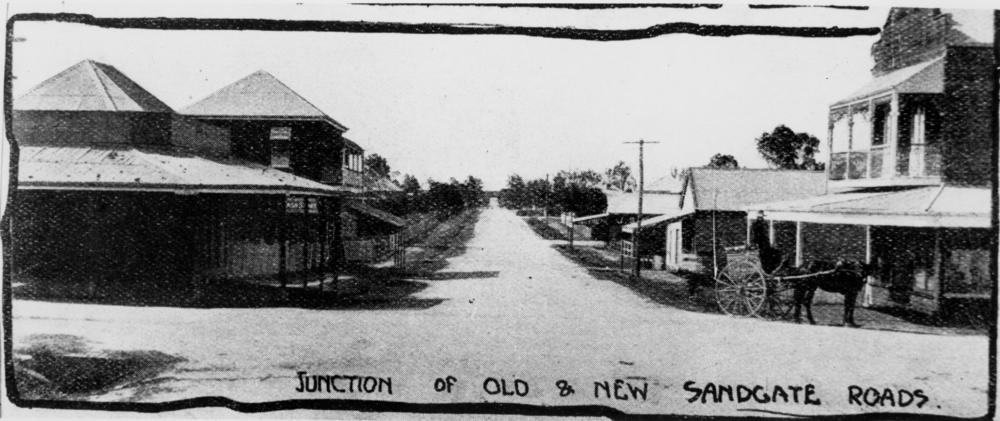
European settlers were already living along Sandgate Road as early as 1838 but the original access to get to Albion was a few miles off, in a street now known as Bonney Ave, which joined Jackson Street in the Eagle Junction area. At that time, this old Sandgate Road was the main link to Nudgee.

The area was often plagued with floods, causing extreme inconvenience and hazard to resiidents and traders, especially during the wet season. Travellers had to get off their wagons and row their produce or baggage across in narrow flat-bottomed boats to continue with their journey.

Soon enough, local demand raised a need to re-route the road to a “new” Sandgate Road, sometime in the 1870s.

Junction of Old and New Sandgate Roads
Photo Credit: State Library of Queensland


New Sandgate Road

To make sure that all concerns were considered, the location and route of the new Sandgate Road was repeatedly surveyed and much deliberated nearly a full decade before it came to be.

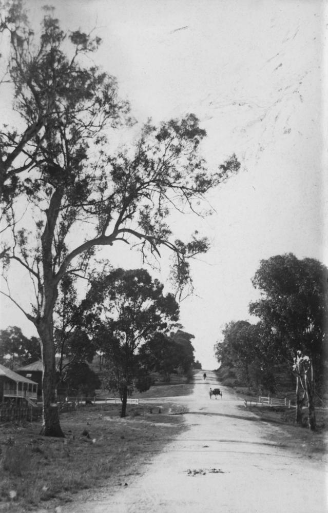
Initially, it started along the stretch of Gregory Street, passing through Clayfield in the northeast beyond the site of what’s now known as the Clayfield Railway Station. During this time, the railway had not even been surveyed yet. The railway would be established decades later.

New Sandgate Road circa 1910
Photo Credit: State Library of Queensland

The land where the new Sandgate Road finally came to pass was bought from William Widdop, Theodor Franz, J. G. Wagner, R. Curtis, and Kate Falkner. The deeds were sub-divided, disposed and signed by 1877. 

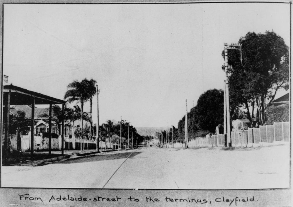
Upon its establishment, the new Sandgate Road became a major route for residents of Clayfield and the surrounding districts, as well as for travellers coming from the river, the Eagle Junction, and the Racecourse Station (Ascot Station), who were headed to Brisbane CBD.

From Adelaide St to the terminus in Clayfield
Photo Credit: State Library of Queensland
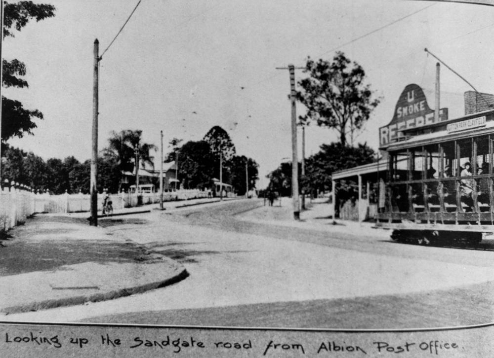
Sandgate Rd from Albion Post Office
Photo Credit: State Library of Queensland

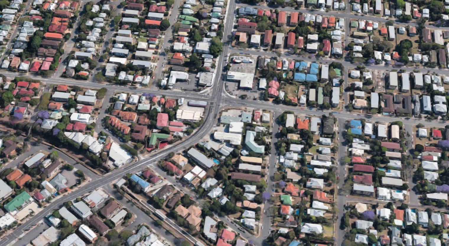
The road had a peculiar, sharp, angular turn near Junction Road, where it veered away from a large paddock that could not be removed without the permission of an owner who could not be located.

Sandgate Rd aerial view
Photo Credit: Google Maps

Road planners also did not anticipate the increasing traffic that commuters had to endure along Sandgate Road until the Hornibrook Highway opened in 1935. Further east, the Gateway Arterial was constructed to ease the pressure and congestion in the area. 

What Happened to the Old Sandgate Rd?

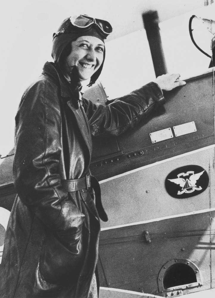
The old Sandgate Road was renamed Bonney Ave for Mrs Maude Rose Lores Bonney, a pioneering Australian aviator, who was born in South Africa, educated in Melbourne, and then married Harry Barrington Bonney, a leather goods manufacturer. The couple settled in Bowen Hills. 

Maude Rose Lores Bonney
Photo Credit: Wikimedia Commons

Mrs Bonney had always been interested in aviation. She took lessons in secret until she got her pilot licence in 1930. When her husband found out, he bought her “My Little Ship,” a de Havilland DH.60 Gypsy Moth. 

Mrs Bonney had four major solo fights. She recorded the longest one-day flight to be ever achieved by an Australian female pilot when she left Brisbane on Boxing Day in 1931 at 4:30 a.m. to arrive in Wangaratta, Victoria at 7:20 p.m. — just in time to spend dinner with her father.


She was also the first woman to circumnavigate the Australian mainland by air and the first woman to fly from Australia to England. She earned her commercial licence in 1932 and also served on the Women’s Voluntary National Register of Queensland during World War II. 

Mrs Bonney retired from flying in 1949 when her eyesight started to fail. She died at the age of 96 in 1994.